


Whatever the geophysical survey type, I always believe in looking at the bigger picture.
First it's important to review historic and regional-scale data such as regional government data, or any open source geophysical data that may have been conducted over nearby deposits. This can be helpful in identifying what geophysical signatures to look for in the current dataset.
If you are very focused on the current dataset you can't always draw out the regional-scale features which may be of importance.
Taking more regional data into the analysis can not only help define regional scale faults with the current dataset, but sometimes even validate questionable anomalies. For example, features of interest may be better defined in the earlier datasets, depending on line directions, line spacing, flying heights, etc.
The following images are taken from open source data in the Timmins area.
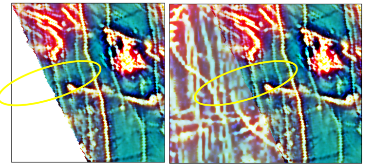
The image on the left shows the newer dataset with a line direction of 045° and a line spacing of 150 m. The image on the right shows the newer data superimposed over an older dataset (slighter lighter intensity of colour) which was flown in a north-south direction with a line spacing of 200 m.
The fault circled is not clearly identified in the newer dataset (due to the line direction) but can be seen easily in the older data.
To gain better insight into current geophysical datasets, it's important to acquire and make use of previous available work. Taking that bigger picture view can enrich the analysis by adding more information to the dataset, and helps see the current dataset in a broader geological context.
This is an important tenet of Ronacher McKenzie Geoscience. We specialize in integrating exploration datasets in 3D, including geological, structural, geochemical and geophysical data. By interpreting the information in a geological context, we get the most out of the data, with the best value for our customers.

