Lately, you may have heard about ‘machine learning’ or ‘artificial intelligence’ with respect to applying it to mineral exploration projects.
The reality is, we are overrun with datasets: drillhole data, petrophysics, airborne geophysics, ground geophysics, inversions, sampling data, structures, mineral chemistry, mapping and many other types of field data. We can get these datasets digitized and displayed in 3D, which ten years ago was still rather uncommon, but then what? There is only so much that the human eye can process visually.
Viewing this data in 3D may give us a warm and fuzzy feeling, but it does not allow us to process the data and use them for prediction. Are we getting full value from all of this data? Are we truly able to relate it all and extract the meaningful relationships behind it?
Thinking about these multiple datasets is akin to thinking about multiple dimensions. Stephen Hawking noted, “Evolution has ensured that our brains just aren't equipped to visualise 11 dimensions directly. However, from a purely mathematical point of view it's just as easy to think in 11 dimensions, as it is to think in three or four.” (Brockes, 2005).
He may have been referring to string theory, but the same goes for exploration datasets. Can we, at a point in space, relate the geology, geophysics, geochemistry and somehow use this information to make a prediction about similar conditions nearby? Can we characterize mineralization or barren rocks, and use this to find more mineralization?
Enter machine learning.
Machine learning as a field of computer science has been around for a while. In 1959, Arthur Samuel defined it as “the ability [for computers] to learn without being explicitly programmed”. Through pattern recognition and computational learning theory, the computer can learn and make predictions on data, through building a model of sample inputs (Munoz, 1959).
Exploration datasets are the perfect tools to apply this approach: we have some knowns from drilling, and several unknowns in the surrounding areas.
Ronacher McKenzie Geoscience has been experimenting with machine learning algorithms, and the results are very exciting.
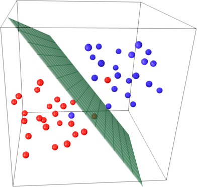
 We are feeding in questions such as: Can we use machine learning to differentiate between barren and mineralized rocks and to predict where the best targets may be? The algorithm takes a subset of data to create a training dataset, in the learning phase. The algorthim then creates a “hyper plane” that best divides the dataset into two clean groups (diagram). For example, the hyperplane may best separate barren and mineralized rocks, based on petrophysical parameters. Once the learning has been completed, the results are applied to the samples outside of the training dataset, and these results are then reviewed for their precision of prediction.
The human brain may be able to relate two or three datasets with each other, but machine learning allows us to work in hyperdimensional space: in exploration, we typically deal with more than one or two datasets (rock type, alteration, multi-element data, various geophysical data). Machine learning helps us to integrate all these datasets, understand the underlying relationships, and make predictions about where the best targets may be located.
Applying machine learning does not mean that we do not need geologists and geophysicists. Humans still need to evaluate the machine output. Humans are still the ones to go to the field to assess the rocks but machine learning will help them prioritize, make their work more efficient and make targeting more successful.
However, exploration scientists and the mining industry cannot turn their backs to this new and emerging technology. It is the way of the future, and we think it will be vital in our collective quest to discover new ore deposits more efficiently.
References:
Brockes, E. (2005, September 27). Return of the time lord. The Guardian.
Munoz, A. (1959). Machine Learning and Optimization. Courant Institute of Mathematical Sciences, New York, NY, 14. Retrieved from https://www.cims.nyu.edu/~munoz/files/ml_optimization.pdf
Photo Credits:
Hyperplane Diagram - source


